Showing posts with label Maps. Show all posts

Saturday, October 24, 2020

Your American Ancestral Map


How many US states and Canadian provinces are associated with your family history? The question was asked as a survey sent this week from the New England Historic Genealogical Society. It's an interesting question if your ancestors, like mine, have lived for many generations in North America and have migrated from place to place. I was surprised at the number of states where my ancestors were born, lived and/or died.

So I invite you to grab a map and your pedigree chart and follow the trails of your various ancestral branches. The NEHGS was specific in their survey about not counting cousin locations and not counting short stays, but rather having a real ancestral connection to a place. But your curiosity can take you wherever you like.

My total was 25 states, plus unexpected burials in a 26th state and in Mexico. Those burials are quite a permanent connection, but not exactly a family association. For several end of line ancestors, I know a state of birth or of residence, but nothing about their ancestors who lived and perhaps died in those states.

NEHGS, with their focus on New England, asked about Canadian provinces, but not Mexican states. That is an unfortunate omission, as the US truly is a melting pot. My grandchildren would add locations in New England, Canada and Mexico to their maps. 

I hope you are inspired to map your ancestral history -- here's mine.


Monday, April 22, 2013

Mappy Monday -- American Waterways

On this Earth Day, 2013, what better topic to consider than our waterways. The news is full of tremendous flooding in the American midwest, tsunami debris washing up on the Pacific coast, shrinking of the polar ice caps and, of course, pollution of the world's waters.

Our ancestors also thought a lot about water. Whether digging a well, traveling by boat or crossing the desert, they had to consider the role of water in their lives. But there was one dependency on water that we rarely think about in the modern world -- the identification of physical property.

In the original 13 colonies and other states settled under the metes and bounds system, the identification of a waterway was important to determine the location of the land. You've seen these land descriptions. They are very convoluted and confusing. The trees, the rocks and the neighbors define the boundaries, along with distance and compass direction.

For a long time I thought the waterway included in the definition meant that the land actually fronted on that body of water. But I learned in a class that the property might not be close to the named waterway. Rather, the land is within the watershed of the named waterway.

Finding such a property on a map may be a bit difficult. A program such as Deed Mapper can draw the outline of the property. It's also possible to draw the dimensions by hand, though it's not my idea of fun. With a rough sketch of the property, it may then be possible to find it on a modern map. The historical dimensions may still be visible in fields and roads that exist today.

Let me take you down a recent research path of mine to see how modern maps can be used with historical deeds.

I learned that my ancestor owned a farm in the Turner Creek watershed of Yadkin County, North Carolina. Fortunately, one of the clerks in the Register of Deeds office in Surry County knew the location of the creek. This is a case where field work was very helpful to the research process.

First search Google Maps for "Yadkin County, NC" to get the county outline.


Zooming in to the lower right corner of the county shows where the creek feeds into the Yadkin River. It's the top little creek.


Zoom in a bit more and the county lines disappear, but the creek changes from a short line to a much longer one, with the name shown.


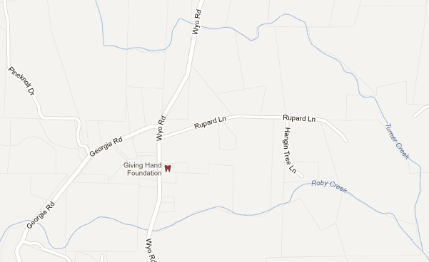
Keep zooming and the modern property lines appear in a darker gray.


If I had the property diagramed, I could now attempt to match it up to the properties near Turner Creek. I would need to look along the length of the creek and between Turner Creek and other waterways, such as Roby Creek in this example.

I hope this brain dump gives you some useful tidbits about waterways, old deeds and modern maps.